Blog 2015

Latest

Posted On: October 22, 2018
Posted On: September 10, 2018
Posted On: June 11, 2018
Posted On: April 23, 2018
Posted On: April 02, 2018

Subscribe

Via Email:

HURRICANE JOAQUIN GIVES UP A CLUE

Posted On: November 04, 2015

According to the Associated Press, Searchers have located what is believed to be wreckage of El Faro

The AP reports that on November 1, 2015 8:30 AM,  Investigators will use a deep ocean vehicle to help confirm whether wreckage that searchers found in 15,000 feet of water east of the Bahamas is the cargo ship El Faro that vanished during Hurricane Joaquin.

The U.S. National Transportation Safety Board said in a statement from Washington that a remotely operated vehicle will be sent deep below the ocean surface in an operation that could begin as early as Sunday. The El Faro went missing Oct. 1 with 33 crewmembers on heaving seas.

Authorities also said late Saturday that they want to survey the wreckage and locate a voyage data recorder — or the ship's "black box" — that could yield clues as to what happened.

An NTSB statement said a specially equipped Navy vessel located wreckage Saturday afternoon in the area of the ship's last known position. It said the wreckage is "consistent with a 790-foot cargo ship, which from sonar images appears to be in an upright position and in one piece."

The 790-foot El Faro was reported missing east of the Bahamas, according to the Coast Guard.

Saturday's announcement by the NTSB, which is investigating the disappearance, came after a ship it contracted for the search from the Navy, the USNS Apache, had spent days combing those waters.

"To confirm the finding, specialists on Apache will use CURV 21, a deep ocean remotely operated vehicle to survey and confirm the identity of the wreckage. This survey could begin as early as November 1," said the statement emailed by Peter Knudson from the NTSB's public affairs office in Washington.

The El Faro's captain had called in before the vessel disappeared saying the ship had lost its engine power during its voyage from Jacksonville, Florida, to San Juan, Puerto Rico. The captain, Michael Davidson, said the ship was listing, and taking on water.

0

STATE POLICE SHOOT BLIMP

Posted On: November 02, 2015

NOW THAT'S A TURKEY SHOOT!

By now we have all heard the story of the wayward government spy blimp with the sensitive equipment aboard it that somehow floated away last week. But what we haven’t heard much about is the not so sophisticated method used to take it down.

Seems some Pa. State Police got some target practice. Here’s a quick short from the AP story

MUNCY, Pa. (AP) — State police used shotguns Thursday to deflate a wayward military surveillance blimp that broke loose in Maryland and floated for hours before coming down into trees in the Pennsylvania countryside.

Curious residents trickled into a staging area as the military began gathering up some 6,000 feet of tether, the blimp's huge hull and a smaller tail piece, a process expected to take at least through Friday.

The white behemoth still had helium in its nose when it went down in a steep ravine on Wednesday afternoon, and the easiest way to drain the gas was to shoot it, U.S. Army Captain Matthew Villa said. State police troopers peppered the blimp with about 100 shots.

The slow-moving, unmanned Army surveillance blimp broke loose from its mooring at Aberdeen Proving Ground and then floated over Pennsylvania, causing thousands of electrical outages as its dangling tether took out power lines.

The 240-foot helium-filled blimp, which had two fighter jets on its tail, came down near Muncy, a small town about 80 miles north of Harrisburg, the state capital. No injuries were reported.

Very sensitive electronics onboard have been removed, Villa said. The military is considering using helicopters to ferry the wreckage from the site, he said.


0

WTF....IT'S COMING

Posted On: October 28, 2015


Mysterious UFO dubbed 'WTF' scheduled to slam into Earth next month

Researchers have discovered some space junk hurtling toward Earth, and they aren't exactly sure what it is.

The appropriately titled WT1190F is expected to hit Earth Nov. 13 -- or "WTF" for short. It's likely a piece of debris left by man from a previous space mission, maybe even one of the Apollo missions. But since scientists don't know technically what it is, that means it's a UFO.

Important reminder: A UFO is any unidentified flying object, not just one of suspected alien or supernatural origins.

"WT1190F" isn't expected to inflict any significant damage to Earth, since much of it will probably burn up in the atmosphere. The remaining portion that does make it to Earth is expected to land in the Indian ocean near Sri Lanka, meaning we may never know exactly what the mysterious debris is.

The discovery is helping scientists track objects as they come toward Earth, which could potentially be more important if a larger projectile should fly into the planet and have a considerably larger impact

0

HOW DID HURRICAINE PATRICIA GROW SO FAST

Posted On: October 26, 2015

This past weeks storm really seemed to catch many by surprise. It went from a small item on a newscast to a major event.

Here's the AP story, I'm still shaking my head. A True Perfect Storm

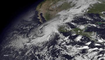
WASHINGTON (AP) — Hurricane Patricia zoomed from tropical storm to record-beater in 30 hours flat like a jet-fueled sports car.

Why? The Pacific storm had just the right ingredients.

Plenty of warm water provided the energy for what meteorologists call explosive intensification. The air was much moister than usual, adding yet more fuel. And at the same time, upper-level crosswinds — called shear — that restrain a hurricane from strengthening were missing for much of Thursday, meteorologists said.

"I was really astounded," said MIT meteorology professor Kerry Emanuel. "It was over the juiciest part of the eastern Pacific."

El Nino's fingerprints are all over this, meteorologists agreed. And while it fits perfectly into climate scientists' theories of what a warming world will be like, they say global warming can't quite be blamed — yet.

At 10 p.m. EDT Wednesday, Patricia was a tropical storm off Mexico with 65 mph winds that forecasters expected to intensify rapidly. In fact, one forecast gave it a 97 percent chance of getting stronger fast.

But it strengthened so quickly that many were surprised, said Robert Rogers at the National Oceanic and Atmospheric Administration's Hurricane Research Division.

By 4 a.m. EDT Friday Patricia's winds were a record for hurricanes: 200 mph.

"Incredible. You don't see many like this," said former hurricane hunter meteorologist Jeff Masters, meteorology director of the private Weather Underground. "In fact in the Western Hemisphere, we've never seen anything like this."

In the Eastern Hemisphere, satellite estimates measured Typhoon Nancy at 215 mph in 1961 and Typhoon Violet at 205 mph also in 1961, but satellite measurements aren't as precise, Masters said. (Hurricanes, typhoons and cyclones are all the same thing with different names.)

Super Typhoon Haiyan that devastated the Philippines in 2013 was measured at 195 mph via satellite. However, most storms don't have accurate measurements because most don't get planes flown into them unless they are a threat, Emanuel said.

He's part of an experiment with the U.S. Navy, dropping measuring devices from planes into Patricia for the past three days.

Worldwide, this is the ninth Category 5 storm this year, which is tied for the second most on record, Masters said. Normal years are around five to six. A Category 5 storm has winds of 157 mph or higher.

The eastern and northern Pacific regions have had more tropical storms than usual this season; the Atlantic has had less.

That's a classic signature of the weather pattern called El Nino — with warmer waters to feed storms and favorable winds in the Pacific and unfavorable winds in the Atlantic, Masters and others said.

Patricia is being fueled by near-record warm 87-degree Pacific waters at the surface that ran warm unusually deep.

Climate science theory says that as the world warms, the most extreme storms will get even stronger and wetter. Patricia's record strength is "consistent with what we say" but there are too few examples to make a scientifically accurate connection, Emanuel said.

Patricia and Haiyan from 2013 may be "warning signs that, hey this could be the future," Masters said.

0

EL NINO AFFECTS NATURE'S DELICATE BALANCE

Posted On: October 21, 2015

 El Nino's Effect On Marine Life Goes Beyond Sea Snakes on a Beach

By Samantha Cowan | Takepart.com

 So I've had people ask, why Care about El Nino? The natural balance gets tilted and some crazy things start to happen

El Niño’s Effect on Marine Life Goes Beyond Sea Snakes on a Beach

Thanks to El Niño, California beachgoers have more to worry about than shark attacks and a deluge of sewage and plastic: Now highly venomous sea snakes are washing ashore too.

On Friday, a surfer found a yellow-bellied sea snake slithering in the sand at Silver Strand beach in Ventura County, about an hour north of Los Angeles, the Los Angeles Times reports.

It’s the furthest north along the Pacific Coast of North America that the black and yellow sea snake  has ever been spotted, and the first time it’s been seen in California since 1985—which was also an El Niño year.

The snake is typically found in warm tropical waters, which, owing to this year’s El Niño  conditions, California beaches now provide. The snakes don’t travel well on land, and the captured yellow-bellied snake died in transport to the local U.S. Fish and Wildlife Service office, according to the Times.

El Niños occur every two to seven years, disrupting winter weather across the country. Scientists have linked rising global temperatures to more severe El Niño events. The National Oceanic and Atmospheric Administration lists this year’s El Niño as one of the strongest on record—and it’s hurting more wildlife than just one scary snake.

A Boon for Fishermen, a Bummer for Tropical Fish

A few miles off of San Diego, fishermen are reeling in exotic fish such as bluefin tuna, yellowtail, and dorado. Though these fish are typically found in Mexico, the four- to five-degree increase in water temperature has created a successful fishing season for Southern California,

Crustacean Crisis

Thousands of crabs found their way to shore in San Diego and Orange County, California, this summer, Prompted to travel north owing to El Niño–triggered warm weather, the crabs struggle out of water, leaving the beaches coated in dead red crustaceans.

Struggling Seabirds

Seabirds are dying at an alarming rate in Northern California, according to the Sacramento Bee. The International Bird Rescue Center has seen an influx in starved common mures, which typically feast on fish below the surface. The warm waters have pushed the fish deeper into cold waters, and the mures simply can’t reach them.

The Phytoplankton Effect

A whole host of marine animals feast on phytoplankton, including whales, jellyfish, and shrimp. As El Niño weakens upwelling of cool nutrient-rich water to the ocean surface, the amount of phytoplankton decreases. Because phytoplankton make up the bottom of the ocean’s food web, decreased supplies affect not only the fish that eat them but those animals’ predators as well. The appearance of hammerhead sharks in waters off the California coast in recent months is because of an increased hunt for food sources, mainly smaller fish and squid, according to wildlife experts.


0

OCTOBER BOATING

Posted On: October 19, 2015

WHY WE LOVE LOVE FALL BOATING


Picturesque landscapes

We can all appreciate green trees, white sand and a bright blue sky… but there’s something really special about cruising amongst the rich orange, red and yellow trees fall is known for, too! In most places, there will be a noticeable difference in the look of your surroundings in the coming months, so that’s something to look out for. Some boaters will even take their fall excursions a step further and plan a destination trip specifically to see these beautiful autumnal changes! If you choose to do this, just be sure to check your destination’s color change “peak time,” since somewhere like Georgia may see fall leaves come in later than, say, Maine. In colder climates, this is a great time to go out and enjoy the changing landscape before winter rolls around.


More comfortable cruising

Whether you live up north or down south, you’re probably ready to say “goodbye” to at least one part of summer: high temperatures! The start of fall means the start of a gradual cool-down trend that we can all enjoy… at least for a little while! Those farther to the north can use the next month or two as a pleasant bridge into cooler, less boat friendly days; meanwhile, those who live in warmer climates can enjoy the cooler (but still bearable) temperatures to come. There’s nothing like crisp autumn air to make us excited to be outside!


Quality time

Between kids’ school days and your own work commitments, you probably have more time to boat during summer than in fall—but during the fall season, you may find that your love of boating and family time grows even more. The activities that were so easy to do in summer—weekend cleanings, spur the moment getaways, simple time spent with family—suddenly become all the more special.

Speaking of quality time… less time on the boat doesn’t have to be a negative! Use your added downtime to catch up on your favorite travel or boating magazines, brush up on key skills or get some cleaning in.


Better deals

The boating off season comes with one big bonus—better deals! During the fall months, be sure to visit boat shows and expos and take a look at what seasonal sales may be going on. You may be surprised to find that your dream boat is a bit more in reach than you previously thought!

While we traditionally think of warm fires and pumpkin picking when it comes to fall, we as boaters know there’s so much more to the season! What are your favorite parts of fall? Be sure to let us know in the comments as we prepare to make the seasonal switch!

0

NATIONS FIRST OFFSHORE WINDFARM BEGINS TO TAKE SHAPE

Posted On: October 14, 2015

FOUNDATIONS LAID FOR BLOCK ISLAND WIND FARM

 The seascape is changing near Block Island.

The Block Island Wind Farm is beginning to take shape three miles off the southeast coast of the island. Two of the five steel foundation components have been installed and affixed to the seabed. Foundations for the five turbine, 30-megawatt wind farm, will be sitting in about 90-feet of water. The crane being used to install the wind turbine foundations is the largest crane on the east coast with its 210-foot boom. The Block Island Wind Farm is expected to be operational by the fall of 2016.

0

El NINO TOO BIG to FAIL

Posted On: October 12, 2015

Get ready for a wild winter, that is , if you believe NASA

 According to a story in the LA times,  Climatologists are predicting that this winter will be unusual across the country because of El Niño that is brewing in the Pacific Ocean.

"There's no longer a possibility that El Niño wimps out at this point. It's too big to fail," Bill Patzert, a climatologist for NASA's Jet Propulsion Laboratory, told the LA Times. "And the winter over North America is definitely not going to be normal."

Scientists say El Niño is getting stronger because of rising sea-level ocean temperatures in the Pacific Ocean and a change of directions of the wind along the equator.

According to the LA Times, that means that winter storms that normally drop rain in central America could shift north and move them over California and the southern United States.

Mike Halpert, the deputy director of the Climate Prediction Center, said this El Niño is the second strongest he's seen at this time of the year.

"This could be one of the types of winters like in 1997-98," Halpert said.

According to NOAA, the winter of 1997 was the second warmest and seventh wettest on record. Severe weather included flooding in the southeast and California, an ice storm in the northeast and tornadoes in Florida.

During that winter, Oklahoma had some of its warmest temperatures and wettest weather.

Patzert told the LA Times that while nothing is ever guaranteed, he is almost certain this El Niño will have an impact. In fact, he says even if temperatures were to start dropping now in the ocean, it would still impact precipitation this winter.


0